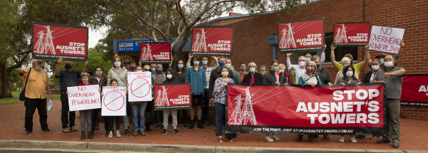
A federal government senator has joined the growing chorus of calls for the Western Victoria Transmission Network Project to be sent back to the drawing board.
Victorian Senator Sarah Henderson said running high voltage powerline project across “some of the best farming land in Australia” shows “utter contempt” for farmers and regional communities.
The Western Victorian Transmission Line Project is being planned by the Australian Energy Market Operator (AMEO) and built by AusNet, to bring renewable energy from the state’s west to Melbourne.
The project has met with firm resistance from the community and been blasted by Moorabool council, with calls for the lines to be buried underground or rerouted.
Ms Henderson said the project will severely impact on agriculture and must be rerouted and redesigned.
“Farmers won’t be able to use drones or helicopters for spraying, spray gun irrigation will be heavily limited and the productivity of farming land will fall dramatically,” she said.
“Apart from threatening some of Victoria’s best farmland and tourism ventures such as local wineries, the proposed route, which runs south of the Lerderderg State Park, also poses a fire risk given its proximity to areas of high bushfire risk.”
Star Weekly recently reported that federal Ballarat MP Catherine King – the opposition spokeswoman for infrastructure, transport and regional development – has also demanded project proponents go back to the drawing board to avoid impacting communities and farming land along the 190-kilometre route from western Victoria through Mooraboool and on to Sydenham.
State government Buninyong MP Michaela Settle also recently called for the proposal to be scrapped in its current form, writing to AEMO to ask for all other options to be investigated including undergrounding and alternative routes.
The Environment Effects Statement (EES) for the project remains in its early stages of preparation, with environmental investigations underway.
AusNet is seeking to access properties within the identified corridor to conduct surveys and understand how properties are currently being used.


