Liam McNally
Melton council is one of 30 municipalities to be carved up into single-councillor wards for the next local election.
The change will see the number of wards in the Melton council area more than triple and a tenth councillor added.
Currently Melton council comprises three wards, all with multiple councillors representing them.
Watts Ward is represented by two councillors and covers the northern area of the City including Toolern Vale, Diggers Rest, Plumpton and Taylors Hill.
Coburn Ward covers the main Melton township and the area to the south, from Kurunjang to Eynesbury, and is represented by four councillors.
Cambridge Ward represents the south-eastern region of the city from Thornhill Park to Caroline Springs.
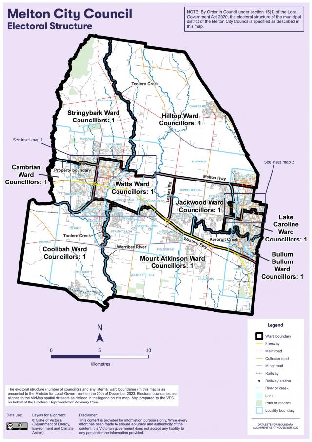
The new structure will carve these three areas into 10 wards. Cambrian and Watts wards focus on the central parts of Melton around the Western Freeway. In the centre-east, the four wards of Jackwood, Sugar Gum, Lake Caroline, and Bullum Bullum focus on suburbs such as Taylors Hill, Caroline Springs, Hillside, and Burnside Heights, while also catering for the growth corridor forming around Aintree and Deanside.
The south of the council is divided into two wards. The south-western Coolibah Ward captures the remainder of Melton South and surrounds, including Eynesbury.
In the south-east, Mount Atkinson Ward caters for the middle growth suburbs of Rockbank and Thornhill Park, which are grouped with other localities south of the Western Highway like Strathtulloh, Ravenhall, and part of Truganina.
The north of the municipality is divided into two wards. The north-western Stringybark Ward captures the northern Melton fringe including Toolern Vale and the north-eastern Hilltop Ward captures Diggers Rest, Plumpton, and part of Hillside.
The panel favoured the recommended model because it captures the large growth corridor running through the middle of the council within six relatively even and compact wards configured along the major transport corridors of the Western Freeway and Ballarat railway line, provides smaller townships and communities along the council’s northern and southern boundaries, namely Diggers Rest and Eynesbury, with a better chance of achieving effective, local representation than other models and makes good use of recognisable features such the Western Freeway, Melton Highway, the Ballarat railway line, Werribee River, Kororoit Creek and Toolern Creek as ward boundaries.
Melton council governance head Megan Kruger said council welcomes the VEC’s final report and thanked residents who made submissions during the review process.


